Completed projects
- Machine Learning aided ForecastIng of drought related eXtremes (MaLeFiX)
- Projecting Sea-Level Rise: from Ice Sheets to Local Implications (PROTECT)
- Cryospheric Monitoring and Prediction Online (CRAMPON)
- Experimental investigation of channelised subglacial flow and till dynamics (LEAD)
- Latest snow modelling approaches for improved mass balance estimates of Swiss glaciers
- Spontaneous rearrangment of ice motion (STREAM)
- Tapping the potential of one decade of annual repeat altimetry to study glacial and periglacial processes (TapRep)
- The Airborne Ice Radar of ETH Zurich (AIR-ETH)
- CCAMM II - Integrating satellite InSAR and feature tracking for early mass movement detection and warning (CCAMM II)
- Frontier GPU multi-physics solvers (GPU4GEO)
- 4D-Antarctica
- Discovering forgotten glacier images in a new glance (DEFOGGING)
- Process-based modelling of global glacier changes (PROGGRES)
- Operational near-real-time glacier monitoring
- Hundred years of Swiss glacier changes from historical terrestrial images
- Basal Processes of Alpine Glaciers: Monitoring and In-Situ Measurements of Stick-Slip Motion
- Potential of long-term water storage from rock glaciers and ice-rock mixtures
- A seismological study of mass movements
- Comprehensive 3D characterization of temperate alpine glaciers using geophysical techniques
- Glacier lake outburst floods and englacial water flow – a full-scale experiment (GLOFFEE)
- Ice volume of the glaciers in the Swiss Alps
- Rescue, documentation and re-analysis of glacier monitoring data
- Towards automated monitoring of alpine mass movements
- Exploring the Hydropower potential of future ice-free basins on a global scale
- Glaciers_CCI - Improved modelling of glacier ice volume
- Resolving the paradox of the Little Ice Age in Europe: Why glacier retreat started before atmospheric warming
- Potential for future hydropower plants in Switzerland (PHP): A study on sediment yields in the glacierized environment of the Swiss Alps
- SHIMP The subglacial hydrology model intercomparison Project
- Inventory of hazardous glaciers in Switzerland

Due to ongoing climate change, drought-related extremes will lead to significantly negative ecologic, economic, and human-health related effects within many different areas. So far, these have mostly been investigated separately. Focusing on the hydro-meteorological aspects, for example, the external page www.trockenheit.ch platform has been developed for informing end-users about dryness in Switzerland, and has recently been enhanced as to include sub-seasonal forecasts. Despite the experience of probabilistic drought forecasting as well as expertise in modelling impacts like forest fire, glacier alterations, bark beetle developments, or biodiversity, there is a lack of understanding of the benefits of forcing such impact models with sub-seasonal (monthly) weather and hydrological forecasts.
The project external page MaLeFiX, led by WSL's group external page Hydrological Forecsts and including a consortium of WSL and ETH scientist, aims at closing this gap between disciplines. It aims at doing so by combining diverse models in a user-friendly and optimal way, and by using state-of-the-art machine learning methods. Our contribution is related to the projection of water yields from glaciers, and of related indicators. The outcome should provide end users with a decision tool, explained in a language readily accessible to stakeholders thanks to the help of results from the social sciences, which allows to detect and prepare for drought-related extremes weeks in advance. The ultimate goal is to gain time for avoiding and mitigating environmental and socio-economic impacts.

The ETH Zurich is part of this a large European project funded in the frame of Horizon 2020. The overarching scientific objective of PROTECT is to assess and project changes in the land-based cryosphere with quantified uncertainties, to produce robust global, regional and local projections of SLR on a wide range of timescales. The project will place particular emphasis on the low-probability, high impact scenarios of greatest interest to coastal planning stakeholders. A novelty in PROTECT is the strong interaction between these stakeholders and the sea-level scientists (ranging from glaciologists to coastal impact specialists) to identify relevant risks and opportunities from global to local scales and enhance European competitiveness in the provision of climate services. The contribution of the ETH Zürich focuses on the global modelling of glaciers both in the past and in the future using GloGEMflow, thus building up on our previous work and other running projects. The focus is on further model development, e.g. regarding ice-flow dynamics and the effect of debris cover, and on a new calibration-validation scheme making use of the full breath of glacier-specific geodetic mass balances worldwide.

How much are Swiss glaciers melting right now? The CRAMPON project investigates the potential of an operational modeling tool to nowcast and predict mass balance and runoff of all Swiss glaciers. We assimilate both field data and near real-time remote sensing observations into the workflow, and use ensemble approaches for uncertainty assessment. The operational tool resulting from this work aims to be one of the first near-real time information web-platforms for glacier mass balance and runoff. This is anticipated to enable better management of hydropower and water resources. In the context of climate services, the tool supports decision making related to electricity production and water allocation.
Taking basic parts of the external page Open Global Glacier Model (OGGM) infrastructure, we set up an ensemble of mass balance models including snow cover processes and albedo aging. Model calibration for each of the approximately 1500 Swiss glaciers is done exploring the suitability of repeated Digital Elevation Models (DEMs) from the Swiss National Forest Inventory (LFI). Model ensemble validation is done with field measurements from the Glacier Monitoring Switzerland (GLAMOS) program and in situ melt observations with on-ice cameras (see also Operational near-real-time glacier monitoring).
Further, the added value of data assimilation for operational glaciological modeling will be investigated. We use extents of melt areas derived from satellite radar data and the glacier snow-covered fraction derived from optical imagery. Different assimilation techniques are compared and their performance is evaluated.
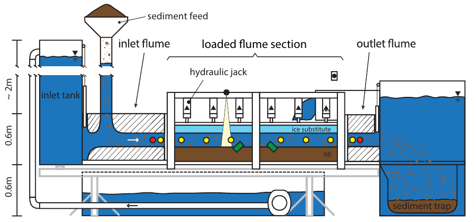
For till-bedded glaciers, subglacial flow and till dynamics are intrinsically connected. While subglacial flow is a feature of glacier drainage, till dynamics can be understood as the temporal evolution of the underlying sediment due to water flow. Subglacial water flow has major impacts on the hydrographs of proglacial streams, on basal sliding and glacier motion, as well as on the dynamics of glacial lake outbursts. Together with till dynamics, the processes affect sediment uptake and evacuation from glacierised environments. Directly accessing the subglacial environment is very difficult and thus, corresponding observations remain scarce. As a consequence, numerical models that aim at representing subglacial processes are poorly tested, and often rely on decades-old parameterisations.
The goal of this project is to overcome these shortcomings by investigating the hydrological and mechanical conditions beneath a till-bedded glacier with physical experiments. For this end, a new laboratory flume will be constructed, in which pressure is applied to the till simulating the weight of a glacier. At the same time, water is allowed to flow along the till-ice boundary. In the early stages of the experiment, we use an ice substitute in order to avoid the otherwise necessary cooling of the entire setup. The new flume will allow for current theories related to till dynamics and the subglacial drainage under till-bedded glaciers to be tested in a controlled environment, and to precisely constrain some key parameters of the related processes.
Accelerating glacier retreat in a warming climate will profoundly impact the hydrology, economy, and ecosystems of Alpine regions and further downstream. Developing effective adaptation strategies is critically dependent on an accurate monitoring of glacier evolution, which is why many countries worldwide have established glacier mass balance monitoring programs. In Switzerland GLAMOS combines in-situ surveys and modelling to provide glacier mass balance estimates for all glaciers in the country. Glacier mass balance is largely the result of snowfall accumulation followed by the melt of snow and glacier ice and is consequently tightly linked to the evolution of seasonal snow on the glacier surface. Yet, most glaciological models ignore complex spatio-temporal snow dynamics induced by processes such as redistribution by wind and avalanches.
This project aims at improved understanding and quantification of the accumulation component of glacier mass balance by use of detailed snow cover model. To this end, we will use FSM2trans, a fully distributed, physically-based snow model which includes snow redistribution processes. In a first step, datasets on snow accumulation on glaciers acquired in the framework of GLAMOS but so far not considered in the development of FSM2trans will allow fine-tuning the meteorological downscaling approaches and model parameters. In a second step, FSM2trans optimized for glacierized areas will be applied to Switzerland’s major glaciers to provide previously unavailable, daily snow distribution maps. Analyzing those in the context of existing operational glacier mass balance products will shed light on the potential of including detailed snow cover process representations in glacier monitoring.
What mechanisms control the spontaneous rearrangement of ice motion in ice sheets? To answer this important question and shed light on better understanding the formation of ice streams in Greenland and Antarctica, we got granted 5'000'000 GPU-hours (equivalent to 80'000'000 core-hours) on the external page LUMI-G machine, the European flagship supercomputer and number 3 in the World (Top500 list). The STREAM project represents a unique opportunity to unleash the Julia language by running the next generation full-Stokes and thermo-mechanically coupled ice flow solvers on more than 3’000 AMD MI250x GPUs. The simulations aim at resolving parts of Greenland ice flow close to meter-scale resolution in 3-dimensions. Regarding the technical aspects, the project will allow to run Julia at scale and use its powerful GPU stack, in particular external page AMDGPU.jl, to target LUMI-G's AMD MI250x GPUs.
The so-called “Spezialbefliegungen” are a data set of very high-resolution aerial photographs and digital elevation models covering about 100 Swiss glaciers and proglacial areas. Since 2012, this data has been acquired at yearly intervals by the Federal Office of Topography in the frame of the Glacier Monitoring Switzerland (GLAMOS) programme. Although both the quality of the data and its spatio-temporal resolution are unique, the resource has been strongly underused so far.
This project sets out to change this, and includes four main activities focusing glaciological and periglacial research questions, as well as data visualization for public outreach. More specifically, the project will (1) advance the extrapolation of glacier mass balance from local measurements to the regional scale, (2) assess the abundance and formation of surface-collapse features on Alpine glacier tongues, (3) quantify periglacial sediment dynamics at the multi-catchment scale, and (4) perform 3D visualization of annual aerial imagery and terrain models for public outreach. These activities will unlock the full potential of a unique data set documenting one decade of climate-related changes in the Swiss Alps.
Knowing the ice thickness of glaciers is essential for a number of applications, ranging from the detection of potential ice-core drilling sites to constraining the glacier’s and ice sheet’s ultimate contribution to sea level rise. In terms of measurement techniques, Ground Penetrating Radar (GPR) is clearly the method of choice. This project – funded by the external page Swiss Polar Institute and conducted in close collaboration with ETH’s Institute of Geophysics and Professorship of Space Geodesy – sets out to re-design the “Airborne Ice Radar of ETH Zurich (AIR-ETH)“, a self-build GPR that is amongst the handful of systems existing worldwide for the airborne surveying of high-altitude glaciers. Weight minimization, inclusion of a fully autonomous positioning system, increases in signal quality, and the boosting of the system’s versatility are the main targets. We envision that the project will result in a system that is deployable both from the air as from the ground in virtually any glacierized region on Earth.
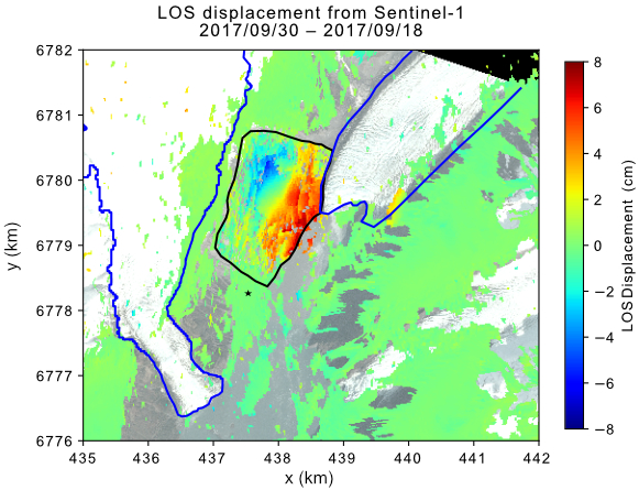
Climate change is rapidly altering mountain environments, increasing the need for reliable tools for the prediction, monitoring, and early warning of alpine mass movements. In this project we integrate satellite-based InSAR data and optical images to monitor slope instabilities, evaluate how meteorological conditions drive slope deformation, and to assess how these driving factors are expected to change under future climate scenarios. Complementing the coarse temporal resolution of the satellite data, we also leverage seismic and infrasound measurements to characterize the subsurface processes driving the instability at Spitzer Stein (BE), catalogue the mass movements at this key location, and train an intelligent detector to identify them in real time. Leveraging the seismic data, as well as automatic avalanche detection systems, this project further exploits recent advances in machine learning to improve the spatio-temporal resolution of avalanche forecasting in Switzerland and assess changes in avalanche hazard due to climate change. This project is in support to the external page WSL initiative external page Climate Change Impacts on Alpine Mass Movements (CCAMM).
Computational Earth sciences rely on modelling to understand and predict the evolution of complex physical systems. Ice sheet dynamics and geodynamics modelling are, despite their apparent differences, two domains that build upon similar physical models and ensuing computational challenges: Extremely large simulations which are not possible with the state of the art in high-performance computing (HPC), thus requiring next-generation supercomputers. Those large-scale simulations are crucial when assessing ice flow dynamics over Greenland and Antarctica, understanding the dynamic motion of Earth’s interior or performing three-dimensional simulations.
The goal of the external page GPU4GEO project is to propose software tools which provide a way forward in these two domains by exploiting two powerful emerging paradigms in HPC: massively parallel iterative solvers, and HPC with Julia on graphical processing units (GPUs). Solvers based on pseudo-transient relaxation show great promise for solving a wide range of mechanical multi-physics problems in geoscience, at scale and on GPU-accelerated supercomputers. We use Julia as the main language because it features high-level and high-performance capabilities and performance portability amongst backends (e.g. multicore CPUs and AMD, NVIDIA).
The 4D-Antarctica project focuses on creating and consolidating an unprecedented dataset composed of ice-sheet wide hydrology and lithospheric products, Earth Observation datasets, and state of the art ice-sheet and hydrology models for the whole of Antarctica. VAW-GL is a Co-PI on this international project lead by Noel Gourmelen (U. Edinburgh, UK) with the responsibility to develop new subglacial water flow models and apply them to the whole of Antarctica. The aim is to enhance our understanding of the subglacial hydrology and its impact on the future development of Antarctica.
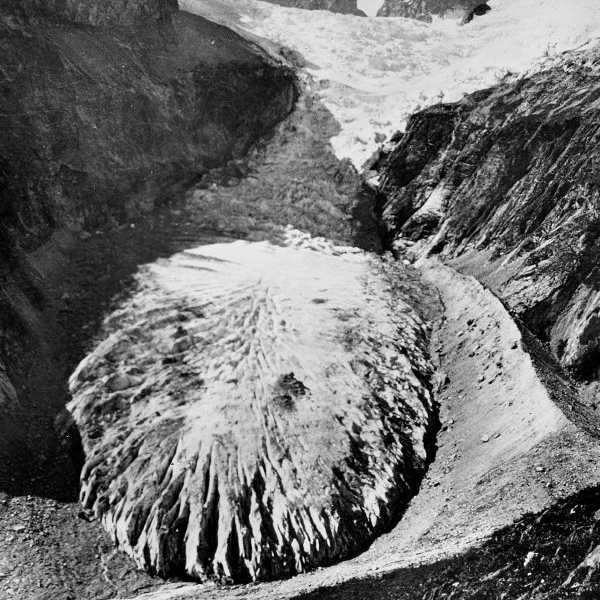
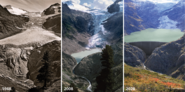
Glacier retreat is one of the most visible signs of ongoing climate change, and repeated glacier photography is possibly one of the most immediate way to visualize and communicate the alarming rate of this change. This project sets out to guarantee long-term accessibility to a unique record of glacier photographs that have been collected over the years. Starting from a pool of over 50,000 images available at the project’s host institution, the aim is to integrate these historic documents in the Image Archive of the ETH Library. The images will be indexed, digitised and georeferenced with the help of volunteers, and made accessible through ETH’s E-Pics platform. This will ensure long-term accessibility to an unique set of observations, thus creating added value for both researchers and the general public. For an already-processed image of Grosser Aletschgletscher in 1927, visit external page smapshot.heig-vd.ch/visit/98525
![Enlarged view: A glacier at the border between Kyrgyzstan and Tajikistan. The project sets out to improve the way by which the future evolution of glaciers can be predicted. [Foto: Daniel Farinotti]](/en/research/glaciology/completed-projects/_jcr_content/par/textimage_1341461007/image.imageformat.lightbox.655511794.jpg)
The worldwide retreat of glaciers caused by ongoing climate change is source of an ever increasing number of concerns: Glacier wastage significantly affects sea-level change, water availability in mountain regions, and glacier-related hazards. Obtaining global-scale information about glacier evolution is thus of utmost importance, and this is commonly done by combining remote-sensing observations with model simulations. To date, however, models operating at the global scale are strongly simplified, and fail to account for some fundamental glaciological processes.
This project sets out to revise both the basis upon which global glacier changes estimates are computed, and the way these estimates can be interpreted. This will be done by harnessing recent advances in obtaining globally-complete glaciological data, and by including some hitherto unaccounted processes into global glacier projections.
The initiative is designed along three work packages. The first is dedicated to model development, and will improve the way processes such as ice dynamics or glacier mass balance are included in global glacier models. The second package will quantify glacier changes in the recent past by developing and applying procedures extracting glacier-related information from achieved satellite imagery. These data will be pivotal for both model calibration and validation. The third package will combine the above advances with the newest generation of climate projections to produce improved predictions of global glacier changes. The analysis of the results will focus on regional-scale differences, and on scenarios that have both economic and policy relevance.
The project leverages recent advances in a number of scientific disciplines and bridges the gap between local- and global-scale assessments that are necessary for the design of strategies for climate change mitigation and adaptation.
![Enlarged view: In-situ glaciological mass balance measurements are demanding, and have inherent limitations in terms of coverage. [Foto: Julia Schmale]](/en/research/glaciology/completed-projects/_jcr_content/par/textimage_702012149/image.imageformat.lightbox.1064973615.jpg)
Glaciers are important elements of the Swiss landscape and knowledge about their changes is of value in a wide range of contexts. The direct monitoring of glaciers in the field, however, is demanding, both in terms of time and manpower. This causes glacier-related information to be intermittent and to have sparse spatial coverage. In particular, reliable information is missing during summer, when the public interest is highest.
This project aims at rectifying this by working towards near real-time glacier monitoring in Switzerland. This will be achieved by combining (i) a set of low-cost sensors that provide glacier-change information on a daily basis with (ii) meteorological data provided by the Federal Office for Meteorology and Climatology (MeteoSwiss) and (iii) numerical glacier models. Whilst the sensors will provide the necessary ground-truth information, the numerical modelling and the meteorological data will allow for the information to be extended in its spatial coverage.
The integration of complementary information sources – notably further field-based data from the Glacier Monitoring in Switzerland (GLAMOS) programme, glacier elevation changes derived from multitemporal digital elevation models of the Federal Office of Topography (swisstopo), as well as satellite data from the European Space Agency’s Copernicus programme – will help to deliver up-to-date glacier information at any point in time.
The project is an extension of the activities pursued within "CRAMPON", and is made possible throuh the external page Global Climate Observing System (GCOS) Switzerland.
![Enlarged view: An example of the pictures by swisstopo that will be processed. [Foto: swisstopo]](/en/research/glaciology/completed-projects/_jcr_content/par/textimage_953695430/image.imageformat.lightbox.1211084196.png)
Switzerland stands out as one of the countries with the longest records of glacier changes, and long-term observations are crucial in order to understand the impact of glacier retreat on water resources or hydropower production. Despite this importance, only a few dozen of glaciers have observations extending further back than three decades
The aim of this project is to process a unique archive of several thousand historical terrestrial images in order to document glacier area, length and volume changes at a centennial scale. The photographs were acquired in the 1920s until 1940s by the Federal Office of Topography (swisstopo) to generate historical maps. A 3D-representation of the largest Swiss glaciers will be reconstructed from stereoscopic image pairs and using modern photogrammetric techniques. These will then be compared to modern topography and yield an estimate of the total ice volume change.
The project is performed in collaboration with the external page Institute of Territorial Engineering (INSIT) and external page swisstopo, and it is made possible through the external page Global Climate Observing System (GCOS) Switzerland.
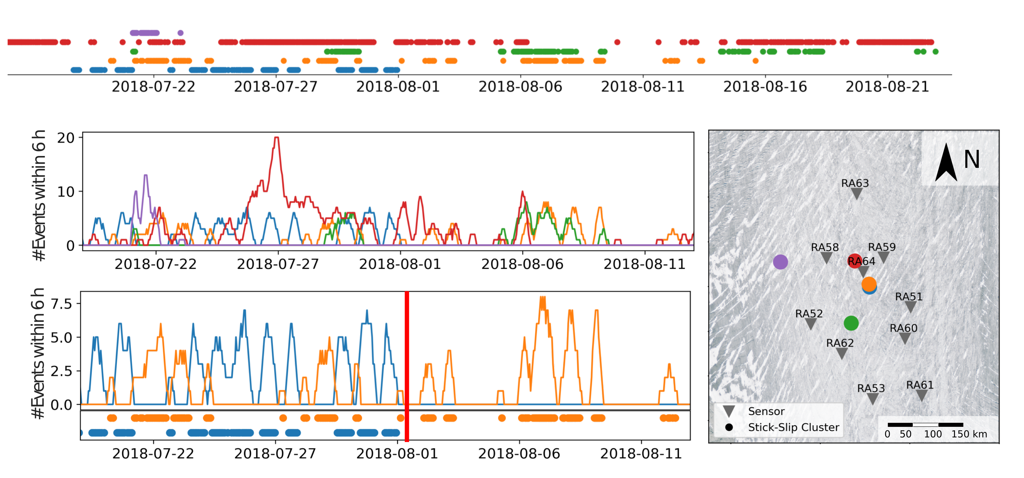
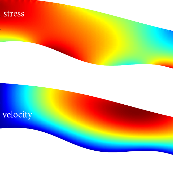
We study tiny earthquakes originating from the bed of alpine glaciers. Some of them, the so-called stick-slip icequakes, are related to the glacier sliding over its bed.
This project investigates microseismic stick-slip motion at the base of Grosser Aletschgletscher, Gornergletscher, Glacier d’Argentière and in particular Rhonegletscher. We want to reveal to what extent seismogenic stick-slip events control glacier sliding and which subglacial conditions influence seismogenic sliding. To do so we recorded unique continuous datasets on the above-named glaciers for more than two years. The seismic data enable us to learn how stress that is built up by frictional resistance is distributed across the glacier (see figure) and compare our findings between study sites.
We not only study microseismic stick-slip events from the glacier surface. We actually drill through the glacier into active seismogenic regions at the glacier bed (example shown in figure, with time when the borehole connected to the bed of Rhonegletscher marked by red bar) to measure stress drop, water pressure drop, and basal co-seismic slip during basal stick-slip events in-situ.
Why is this of interest: First, because basal motion and frictional processes at the bed of large ice streams need to be understood to predict future sea level rise. Throughout this project we leverage the accessibility of the European Alps to gain knowledge about glacier sliding that should be parameterized in ice sheet models. The second interesting part about this project is that we study frictional mechanisms that are very similar to earthquakes, just many orders of magnitudes smaller. We use glaciers with their repeating basal stick-slip as natural laboratories to investigate seismicity and earthquakes, for example at strike slip faults.
Due to ongoing climate change glaciers, mountain permafrost and periglacial features are undergoing rapid changes. When it comes to the water contribution of these elements, clean-ice glaciers have been studied relatively extensively whilst the significance of rock glaciers is less well understood. Rock glaciers are stratified rock-ice features and can be several millennia old. Their characteristic coarse blocky surface layer provides some insulation from atmospheric warming and rock glaciers are thought to be less sensitive to changes in climate. The aim of this project is to estimate the evolution of the thermal regime and potential melt of rock glaciers under future climate scenarios, thus assessing their future potential as water contributors.
The rock glacier’s coarse blocky surface introduces some challenges when modelling their thermal regime. In particular, ventilation effects – that are effects due to either natural convection caused by differential heating at the top and bottom of cavities or to forced convection induced by wind – need to be accounted for. To do so, this project employs the numerical models external page SNOWPACK and the in-house Glacier Runoff Evolution Model – Permafrost (GERM-P). The physics-based model SNOWPACK will be used to gain a deeper understanding of the relevant processes, whilst the conceptual, parametric model GERM-P will be used for applications at the catchment scale.
By using the two models, the project will allow to (a) further improve GERM-P, (b) provide long-term simulations for selected rock glacier sites in the Swiss Alps, and (c) quantify the potential runoff contribution from rock glaciers under future climate scenarios.
This project is an integral part of WSL’s external page Climate Change Impacts on external page Alpine Mass Movements (CCAMM) initiative and builds upon field data collected in the frame of the Swiss Permafrost Monitoring Network (PERMOS).
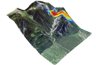
Mass movements, such as rockfalls, debris flows (a mixture of water, sediments and boulders), and ice avalanches, in steep mountain torrents have a highly destructive potential. As alternative to classical monitoring and early warning instrumentation, seismology - the study of ground motions induced by a force within the earth - allows monitoring of mass-movement-induced ground shaking at safe distance to rapidly detect and locate a flow front. The aim of this project is to better understand the dynamics and triggering mechanisms of mass movements in a changing climate.
Traditionally, seismology is associated with earthquakes, where ruptures in the earth crust release elastic energy in the form of seismic waves which then propagate through the earth. In recent years, a new field called „Environmental Seismology“ has evolved, which focuses on seismic signals generated by environmental forces at the earth surface. Advances in instrumentation size and portability allow only lately the deployment of seismometers in remote terrain. Utilizing the knowledge accumulated from decades of research in earthquake seismology, processes of mass movements can be monitored. The project mostly focuses on the Illgraben, a steep mountain catchment in the Valais, which is one of the most active mass wasting sites in Switzerland producing several debris flows per year. To study these, data from recent years as well as data from new deployments in sping/summer 2018 are used. In addition, other study sites are investigated for information on the influence of snow and ice on mass movement processes.
The three main goals of the project are:
- analysis of the process cascade defining mass movements
- early warning system of debris flows on real time seismic data
- numerical modeling of geophysical granular flows in combination with seismic data analysis to investigate rheological properties and effective friction
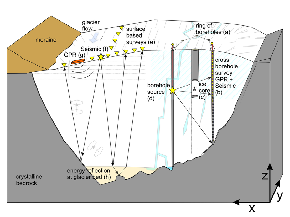
This project will perform a comprehensive 3D characterization of the ice mass using ground-penetrating-radar (GPR) and seismic techniques. The geophysical results will be integrated in ongoing activities geared towards a better understanding of the hydrology of glaciers.
Besides commonly used surface measurements, crosshole surveys using multiple boreholes will be performed. The data will not only be analyzed with state-of-the-art 3D travel time and amplitude tomography, but also with full waveform inversion techniques. This will allow for the fulll the information content of the geophysical data to be exploited. Particular emphasis will be put on analysing the anisotropy of the electrical and elastic ice properties, which will offer key information on the ice structure and thus preferential water flow paths within the ice itself. The geophysical results will be calibrated with laboratory investigations of ice cores extracted at the test sites. For a detailed characterization of the glacier bed properties, joint inversions of GPR and seismic data will be performed. Attribute analyses will allow delineating the bedrock topography, determining the existence of subglacial drainage channels, and identifying the presence of sedimentary layers.
![Enlarged view: Salt water injection to conduct a dilution gauging experiment in artifical drainage canal on Glacier de la Plaine Morte. [Foto: Christoph Ogier]](/en/research/glaciology/completed-projects/_jcr_content/par/textimage_304762228/image.imageformat.lightbox.901324139.png)
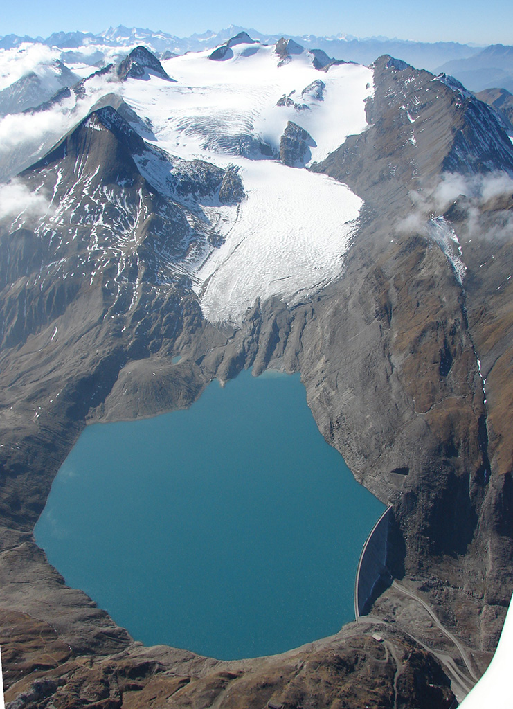
Glacier lake outburst floods (GLOFs) are a natural hazard characteristic of high alpine environments. This project sets out to take advantage of a unique situation emerging at Glacier de la Plaine Morte, Switzerland: With the aim of mitigating an annually-occurring GLOF, the local authorities have decided to construct an englacial channel through which the lake will be drained artificially. The project will perform dedicated measurements during the time that water flows through the artificial channel. Exploiting the unique fact that the initial channel location and geometry are known, the measurements will allow for testing both long-standing theories of englacial water flow and more recently proposed monitoring strategies based on seismics.
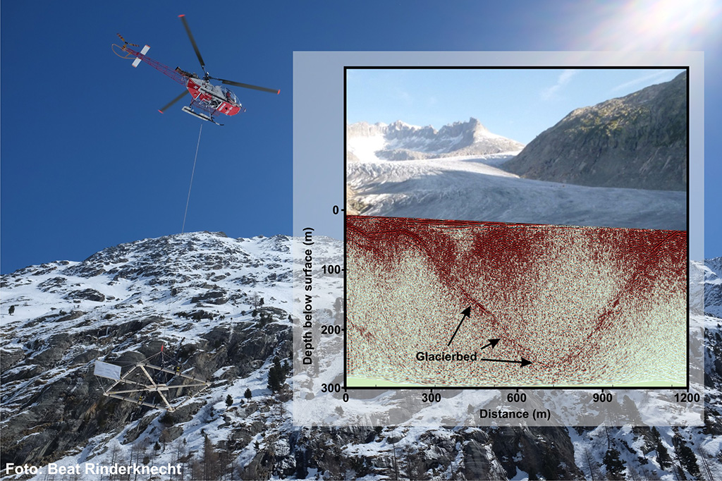
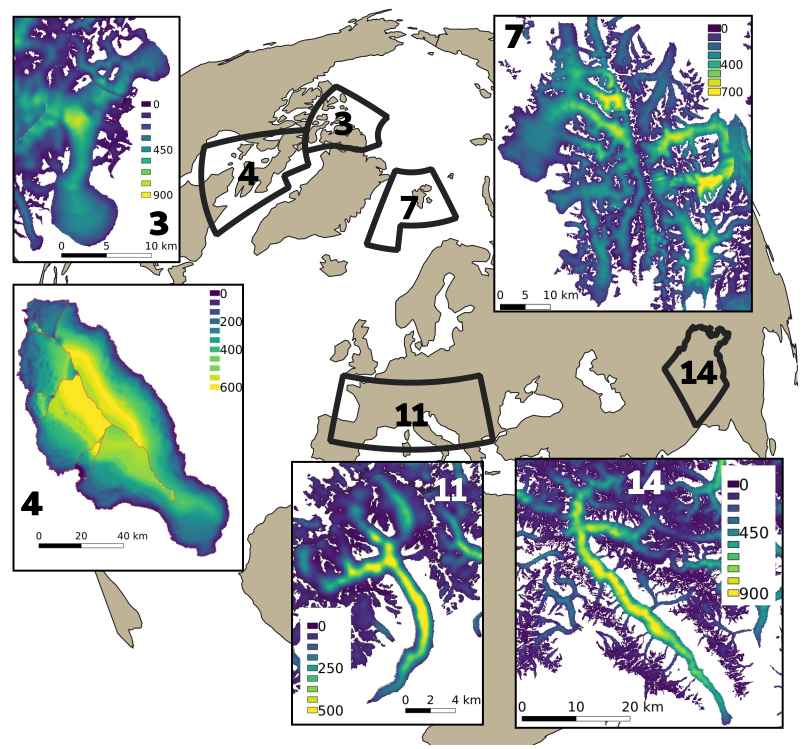
Whilst detailed inventories exist for the Swiss glacier area, only rough estimates are available for the ice volume. Until recently, direct measurements of ice thickness were limited to a few selected glaciers. Over the last 5 years, more than 1500 km of helicopter ground penetrating radar (GPR) profiles have been recorded, supported by the Swiss Geophysical Commission (SGPK) and the external page Swiss Competence Center for Energy Research - Supply of Electricity (SCCER-SoE). The combinations of these data with recently-developed approaches for estimating the basal topography, will allow to obtain new, high-precision estimates of the ice thickness distribution of all glaciers in Switzerland.
This project will focus on the choice of a optimal GPR system, an improved processing scheme, the acquisition of measurements and the evaluation of the total ice volume. Helicopter-borne GPR allows the efficient acquisition of measurements. Different radar systems have been tested in the frequency range of 15 to 70 MHz. Measurements with the same GPR antennas on ground revealed a wealth of useful information on both the glacier bed topography and the technical nature of the system. Based on these results, a new towed radar system based on two orthogonal antenna pairs was constructed and successfully tested. The project will provide better estimates for the total amount of ice stored in the Swiss Alps at present.
![Enlarged view: Mass balance measurements on Swiss glaciers have a long tradition. [Foto: Matthias Huss]](/en/research/glaciology/completed-projects/_jcr_content/par/textimage_462464578/image.imageformat.lightbox.302375189.jpg)
Long-term glacier monitoring in Switzerland has resulted in some of the longest and most complete data series at the global scale. The direct observations of mass balance date back until the late 19th century and, at some sites, have been continued until today. Data acquired in the frame of GLAMOS are stored in a database and documented metadata are available for the more recent measurements. For observations performed before about the year 2000, in contrast, it is often difficult to reconstruct complete sets of metadata. However, accurate metadata are highly important for homogenisation of the in-situ measurements and for tracing the origin of the observations. Furthermore, metadata are indispensable for the re-analysis of the long-term series, including an assessment of their uncertainty.
The present project sets out to significantly advance the documentation of long-term glacier data within Swiss glacier monitoring activities. First, we will target the rescue and homogeneous storage of yet scattered data of seasonal/annual point mass balance (both in printed and digital form). Second, a better documentation of metadata is envisaged allowing full traceability – wherever possible – of the applied measurement methods and the involved uncertainties. Third, we aim at completely re-analysing long-term series of glacier-wide mass balance in order to deliver consistent data sets for further studies. All rescued, documented and homogenized glacier data will be stored and made available for scientific and public needs.
The project is an extension of the activities pursued within external page Glacier Monitoring in Switzerland (GLAMOS), and is made possible through the Global Climate Observing System (GCOS) Switzerland.
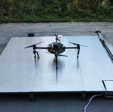
Early warning systems of mass movements often use different instrumentation to detect events. Since the events occur within short time windows, however, observations with static instruments are difficult. This project aims at setting up an interactive network of autonomously communicating instruments to capture processes happening during and directly after alpine mass movements, and debris flows in particular. The investigations will target the Illgraben catchment, Valais. The project's key innovation is to trigger an autonomous Unmanned Aerial Vehicle (UAV) through seismic detections. The UAV will fly along the torrent, and collect imagery of both the flow front and the sediment source areas. Close-range photogrammetry techniques will be used to extract terrain movement. The collected data will allow for insights into debris flow dynamics, provide input for numerical models, and inform risk assessment and mitigation measures.
In this project we analyze new landscapes which are emerging though glacier retreat, and identify locations which may be suitable for potential new water storages and hydropower production once glaciers have retreated. This involves modelling the physical hydropower potential but also taking into account environmental, social and economic factors to assess the feasibility of each location.
The determination of the volume of a glacier is one of the most challenging topics in glaciology. Ice thickness distribution is a necessary input to various glaciological applications ranging from ice flow models, the assessment of changes in local to regional hydrology, to global projections of sea-level rise from glacier melt. Recently, several methods have been developed to derive glacier bedrock from surface topography based on the principles of ice flow dynamics.
In this project we developed a new ice thickness model which uses Bayesian-statistics methods to produce maps of ice thickness from available data, such as surface elevation, ice flow speed and ice thickness measurements. The ice flow speed data is from the main project of Glaciers_CCI (University of Zurich). We applied the model to more that 30'000 glaciers in five regions of the world: Arctic Canada North and South, Svalbard, European Alps and Pyrenees, and Karakoram. Our results show that our method is competitive with existing methods and improves on them by also calculating maps of the error of the estimated ice thickness.
The Little Ice Age in Europe (between about 1350 and 1850) marked the largest glacier extent over the entire Holocene period. However, the causes of the substantial glacier advances in the mid-19th century and the rapid retreat following this phase are yet unclear. The so-called “paradox of the Little Ice Age” refers to the long-standing problem why glaciers in the Alps experienced rapid growth around 1850 and subsequent decline despite air temperatures remaining at a low level until 1920.
In this project, we intended to further develop regional models for glacier surface mass balance and ice flow dynamics at the scale of the entire Swiss Alps in order to shed light on the paradox of the Little Ice Age. We included the important processes of solar radiation forcing and the feedback of surface impurity concentration on snow and ice albedo into a mass balance model with little input data demand (temperature, precipitation). Changes in ice thickness and ice flow speed, and ultimately glacier advance and retreat, have been computed with a three-dimensional model for ice flow dynamics operating at the regional scale. Both models have been coupled and run over the entire period with instrumental data (1760 to present). By performing experiments with various assumptions on the forcing variables using the combined mass-balance ice-flow model, we attempted to reproduce observed maximum glacier extent and measured length changes. This will finally allowed us to attribute glacier response to a combination of different climatic forcing mechanisms – temperature, precipitation, solar radiation, surface impurities/albedo.
Understanding the drivers of the exceptionally fast glacier change around the Little Ice Age maximum is of eminent importance for an improved understanding of glacier sensitivity in the past and at present, as well as and for future glacier projections. In fact, the clear documentation of glacier advance and retreat around 1850 via historical and geomorphological evidence provides the exciting opportunity to study the involved processes and to resolve their relative importance.
With the federal “Energy Strategy 2050” hydropower production is supposed to increase to partly compensate for the planned nuclear power pullout. Besides upgrades of existing hydropower schemes, there is a potential from new developments in newly formed landscapes in front or just beyond the outer limits of glaciers (periglacial zones). The immediate proximity to the glacial environment, however, will pose challenges in terms of construction, operation and maintenance. In particular, the high sediment yields from glacierized and deglacierizing areas are of concern.
The goal of the project was to assess the sediment yields in glacierized catchments of the Swiss Alps. In particular, we provided answers to the following questions: (1) What is the present sediment yield in the glacierized catchments of the Swiss Alps, and what was its temporal evolution over the last decades? (2) What are the causes of the recently observed increase in sediment discharge? (3) What is causing different sediment discharges for different catchments? (4) How will the sediment discharge evolve in the coming decades?
Erosion rates and sediment flux have directly been measured for a set of selected catchments, and the data have been used to develop a glacier-hydrology model which takes erosion and sediment transport into account. The sensitivity of sediment yields to changes in glacier extent and climate forcing has been explored. The developed model is able to capture the temporal evolution of sediment yields within a basin, and provided a framework to understand differences in sediment yields from different catchments.
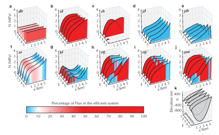
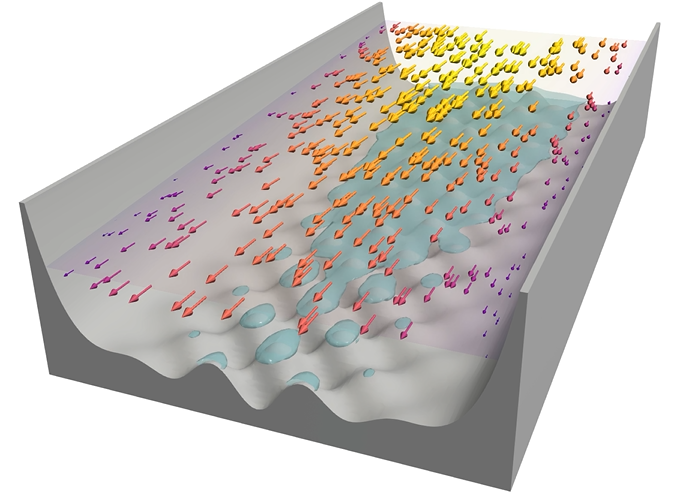
Subglacial hydrology plays a key role in many glaciological processes, including ice dynamics via the modulation of basal sliding. Owing to the lack of an overarching theory, however, a variety of model approximations exist to represent the subglacial drainage system. The Subglacial Hydrology Model Intercomparison Project (SHMIP) puts together a set of synthetic experiments to compare existing and future models.
The study presents the results from 13 participating models with a focus on effective pressure (ice overburden pressure minus water pressure) and discharge. For many applications (e.g. steady states and annual variations, low input scenarios) a simple model, such as an inefficient-system-only model, a flowline or lumped model, or a porous-layer model provides results comparable to those of more complex models.
However, when studying short term (e.g. diurnal) variations of the water pressure, the use of a two-dimensional model incorporating physical representations of both efficient and inefficient drainage systems yields results that are significantly different from those of simpler models and should be preferentially applied. The results also emphasise the role of water storage in the response of water pressure to transient recharge. Finally, we find that the localisation of moulins has a limited impact except in regions of sparse moulin density.
Within the framework of the EU Project GLACIORISK (Survey and prevention of extreme glaciological hazards in European mountainous regions) and a mandate from the Canton of Valais, the Laboratory of Hydraulics, Hydrology and Glaciology (VAW) of the Swiss Federal Institute of Technology in Zurich compiled an inventory of hazardous glaciers in Switzerland. "Glacial hazard" refers to critical glacier fluctuations, glacier floods or ice avalanches. The term glaciers floods includes both glacial lakes and water pocket outbursts. These three types of hazards are closely linked together and, by way of feedback-mechanisms can lead to dangerous or even catastrophic events. The present inventory deals with hazards that threaten life in the vicinity of human facilities (e.g. settlements, communication roads, tourist installations). Inherent mountaineering risks are therefore not considered.
The inventory includes 82 glaciers which in the past inflicted damage on persons or property or for which a potential danger was recognized. Of these, 55 are located in the canton of Valais, 18 in canton Berne, 2 in the cantons Vaud, Uri and Grisons, and one in the cantons of Obwalden, Glarus and Ticino, respectively. According to present assessment, for 51 of these 82 glaciers, potential damage to settlements (23 cases), traffic routes (29 cases) or other man-made installations (water intake, farm buildings, agricultural land, hiking trails, mountain cabins, tourist facilities) (50 cases) must be expected within the next 10 to 20 years. A large number of people pursue various activities within the potential risk zone. At present, there is a monitoring scheme for only 12 of the 51 glaciers, whereas for the remaining glaciers, such a scheme has still to be devised.
A compilation of all inventoried event s showed that since 1595 at least 440 persons have lost their lives in 21 glacial disasters (approx. one event every 20 years, or one victim per year). For 146 events, collateral damage occurred to various human infrastructures (approx. one event every 3 years).
This inventory contains all the information about glacial events and potential risks we could gather from local chronics, glacier reports, publications and newspapers. It does not claim to be exhaustive, some events may have escaped from the observation, or gone unrecorded. As the hazard potential changes with glacier fluctuations (in the context of potential climatic changes), the results of this present evaluation will have to be revised and updated regularly.