Research projects
- Topoclimatic control on glacier Equilibrium Line Altitudes under past, present and future climate change (TOP-ELA)
- Revealing glacier dynamics with distributed fibre-optic strain and temperature sensing (FIBR-ICE)
- Numerical Experiments of soft-bedded glAcier Drainage (NEAD)
- Mining Impacts on Tien Shan glaciers in Central Asia (MITICA)
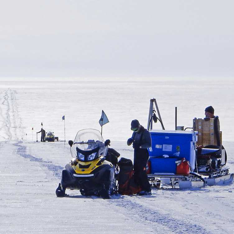
- Glacier Lakes in Antarctica: Drainage, Dynamics, Evolution and Refilling (GLADDER)
- Climate-Space X-ECV ‘Karakoram Anomaly’
- Sensitivity of the West Antarctic Ice Sheet to 2°C of warming (SWAIS2C)
- Contribution of avalanches to glacIer mass baslance at the global scale (CAIRN-GLOBAL)
- Thermal response of retreating mountain glaciers: An assessment of polythermal glaciers (THERMAP)
- Machine learning glacier mass balance models (Massbalance Machine)
- Impact of glacier retreat on slope instabilities
- Dangerous and invisible: water pockets in Alpine glaciers (DIWING)
- 21st century evolution of small glaciers and their impact on regional hydrology in the Himalayas (ETERNALHIMA)

Long-term perspectives on natural glacier-climate interactions are important to understand the causes and consequences of present and future glacier retreat. One way of assessing glacier evolution over centuries or millennia is through tracing changes in the Equilibrium Line Altitude (ELA). The ELA is the average altitude of zero net mass balance at a glacier, at which accumulation and ablation are equal. While its position is primarily determined by climate (i.e. temperature and precipitation), spatial and temporal changes in the ELA can also be controlled by catchment-specific factors, such as aspect, avalanching or wind-driven snow redistribution. The importance of these so-called topoclimatic factors in modulating the ELA has widely been acknowledged, but mostly on a qualitative level and at the regional scale. Combining perspectives and expertise from both glaciology and glacial geomorphology, this project aims at providing a first quantitative assessment of topoclimatic control on glacier ELAs at the global scale. The expected results will allow us simultaneously to better describe present-day glacier-climate interactions, to improve reconstructions of glaciers during the past centuries and millennia, and to provide perspectives on their future fate under global warming.

Advanced optical fiber measurement techniques now enable high-resolution (<1m) distributed sensing of temperature, seismics and strain along a fiber. While Distributed Temperature (DTS) and Acoustic (DAS) Sensing measurements have been applied in glaciology, Distributed Strain Sensing (DSS) remains unexplored in this field. This project will establish DSS and DTS methodologies on a small glacier before employing them on a large polythermal glacier to investigate the crucial relationship between ice temperature and deformation dynamics.
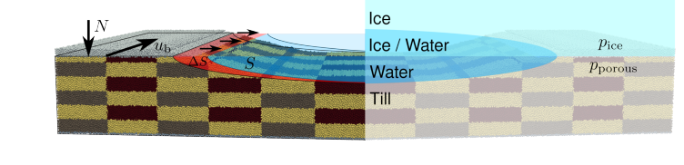
The project "Numerical Experiments of soft-bedded glAcier Drainage" (NEAD) investigates how water flows beneath glaciers resting on soft sediment (till) using small-scale numerical modeling. Its first phase employs discrete element modeling to simulate how subglacial till deforms near drainage channels, with particular attention to the effects of glacier sliding. The second phase will implement a coupled till-ice continuum model to simulate channels carved into both till and ice.
This research aims to enhance our understanding of subglacial drainage systems of soft-bedded glaciers, including many Antarctic ice streams. Improved knowledge of these processes will enable more accurate simulations of ice stream behavior, contributing to better predictions of ice heet dynamics and their response to climate change.
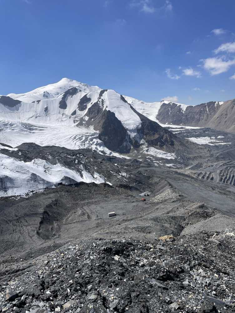
While climate change is the main driver of glacier retreat globally, human activity can also play a significant role locally. The MITICA project explores how the Kumtor Gold Mine, one of the largest gold mines in Central Asia, may be accelerating glacier melt in Kyrgyzstan’s Central Tien Shan region. The project focuses on the idea that mining operations, especially truck traffic and rock blasting, produce dust that settles on nearby glaciers. This dust can darken the glacier surface, lowering its albedo (reflectivity), which causes the ice to absorb more sunlight and melt faster. MITICA combines fieldwork and remote sensing to better understand this impact. Using drones (UAVs), we create detailed maps of glacier surfaces and compare them to older data to track changes in ice thickness. We also collect mass balance measurements and take surface samples for lab analysis to identify dust. By linking dust levels with changes in glacier reflectance and melt, MITICA aims to quantify the impact of mining on glacier retreat. The findings will help improve glacier models and provide important insights for managing mining practices in mountain regions under pressure from both climate and human influence.
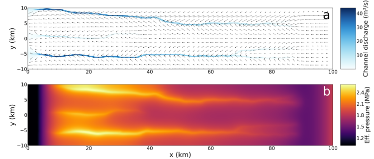
The GLADDER project is an initiative to understand the complex behaviors of subglacial lake systems in Antarctica to set the foundation to assess their impact on ice sheet and ice shelf dynamics and stability. At the heart of this project is the enhancement and subsequent application of the Glacier Drainage System (GlaDS) model; an advanced tool designed to simulate the subglacial drainage system and enhanced to reproduce the intricate processes governing subglacial lake dynamics beneath the Antarctic Ice Sheet.
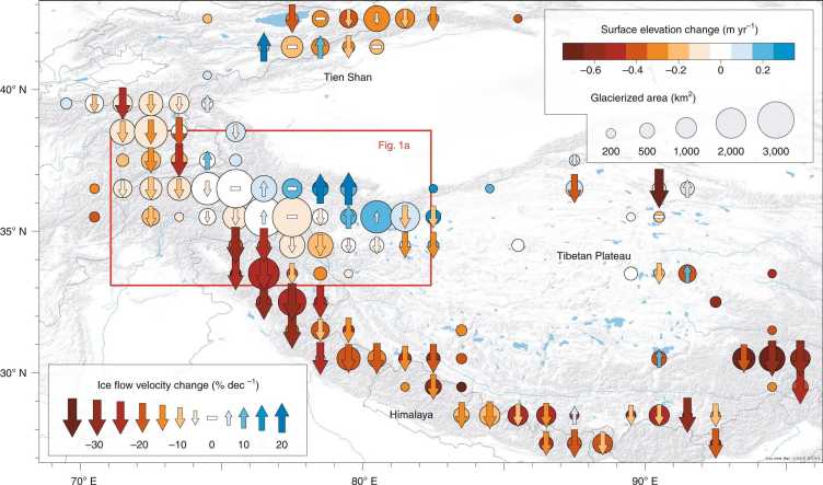
With the Climate-Space X-ECV ‘Karakoram Anomaly’ project, we aim to investigate the widely recognized cryospheric and climatic singularity, the so-called ‘Karakoram Anomaly’ (KA). The KA is expressed by air temperatures that do not increase, glaciers that do not retreat but are stable or even advancing, and glacier mass balances that were close to zero or even positive over the past 20 years. On a 50-year time scale, this is the only larger region on Earth where glaciers have gained mass.
The focus of the research is on three overarching research questions:
- Do the available observations and climate data allow reproducing and explaining the observed glacier mass balance history and its spatio-temporal variability in the Karakoram?
- What is the present climatic sensitivity of the Karakoram glaciers and how will their mass balance change under future climate change?
- What is special about the Karakoram glaciers and is the climatic component of the KA visible in the available data sets at a larger scale?
SWAIS2C examines the Sensitivity of the West Antarctic Ice Sheet to 2°C of warming. To accomplish this we will drill back in time at two sites deep in the interior of West Antarctic. Our international team includes glaciologist, geologists, oceanographers, biologists, and modellers. Together we aim to:
- Determine whether the West Antarctic Ice Sheet has advanced and retreated during the Holocene. This was a period of relatively stable climate that has characterised the last 10,000 years prior to the industrial revolution and the onset of the Anthropocene.
- Determine how marine-based ice sheets respond to a world that is 1.5°–2°C and >2°C warmer than pre-industrial times.
- Understand the local, regional, and global impacts and consequences of the response of the Antarctic Ice Sheet to this warming.
Our first Antarctic field season was 2023-2024. During the 2024-2025 we will return to the grounding zone of Kamb Ice Stream. For more project details and updates see external page www.swais2c.aq
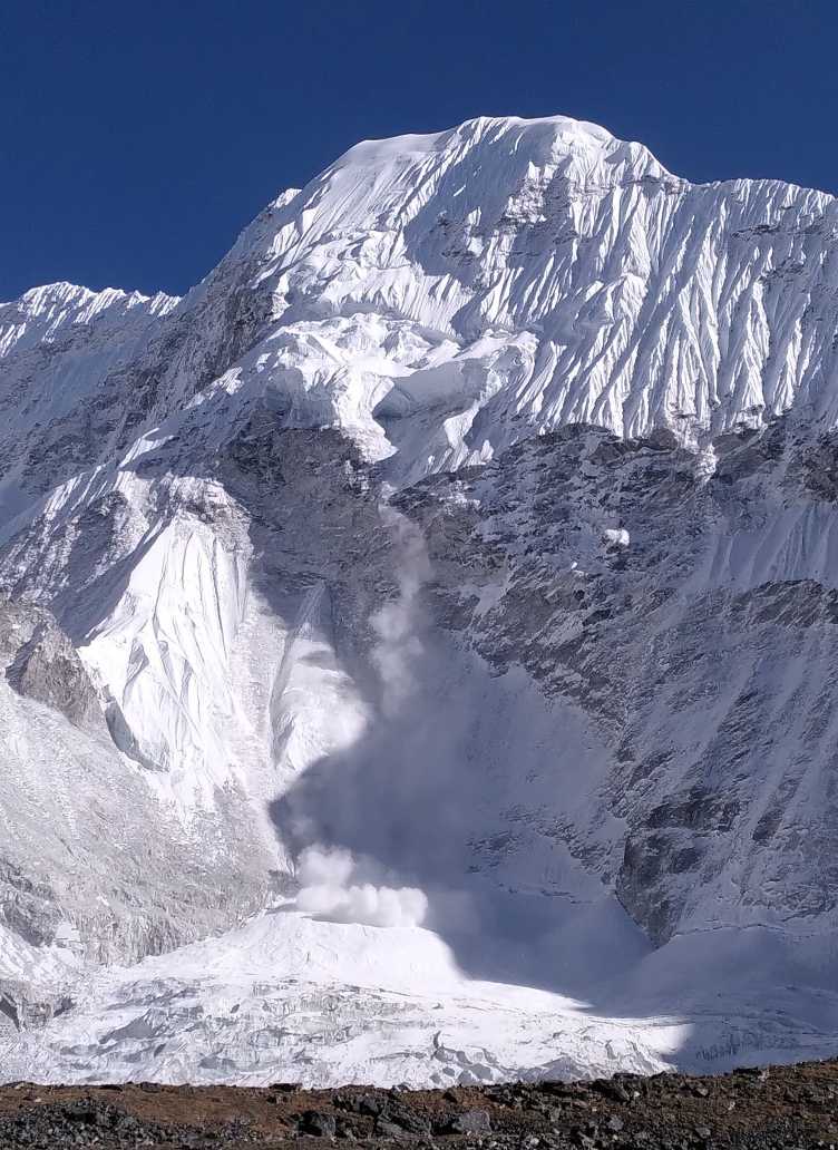
Anthropogenic climate warming is causing rapid melt and retreat of mountain glaciers worldwide, and this is particularly worrying for regions that rely on them for water resources. Future projections of glacier evolution are limited by the ability of current models to represent key processes such as high-altitude accumulation patterns or avalanche contribution to glacier mass balance. On-glacier avalanches channel snow from upper headwalls onto the glacier surface, which can help maintain glaciers at low elevations despite warming temperatures.
CAIRN-GLOBAL is a follow-up project of two-year project conducted at IGE in Grenoble and University of Innsbruck, during which were developed specific approaches to quantify this avalanche contribution from satellite products and field measurements. CAIRN-GLOBAL now aims to expand on this work by developing a coupled glacier and avalanche model that will be run at the global scale to quantify the contribution of avalanches to glacier mass balance for all glaciers in the world. It will therefore allow to point out the regions where avalanching has a significant role by contributing to maintaining glacier ice at low elevations.
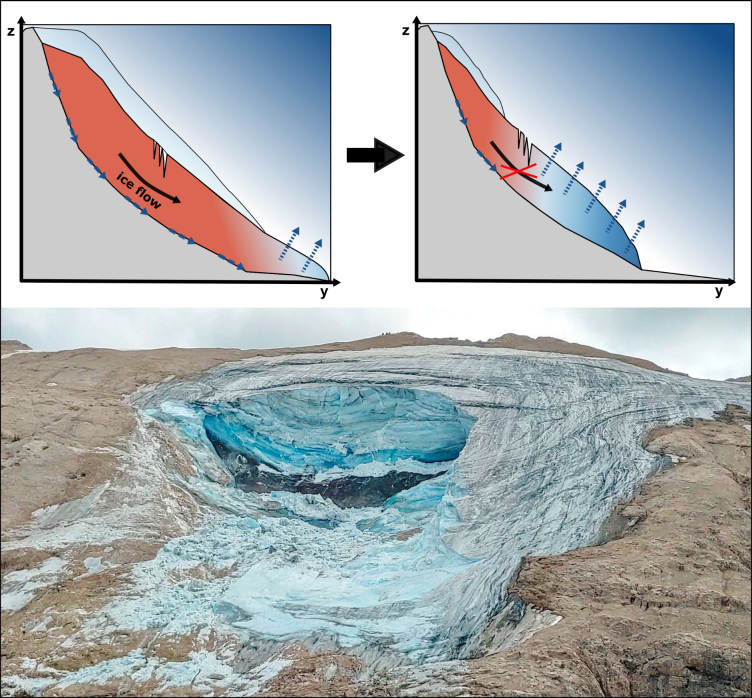
Glacier instabilities pose a significant threat in high-mountain environments, as tragically shown by the Marmolada glacier accident in July 2022. While cold-based ice breakoffs are relatively predictable, instabilities in temperate or polythermal glaciers are not. The Marmolada glacier avalanche has drawn special attention to the risks posed by polythermal glaciers, which are more unpredictable.
Counterintuitively, climate change is contributing to the cooling of some glaciers, which increases the likelihood of polythermal glacier formation. As glaciers shrink and lose mass, their dynamics slow, resulting in reduced internal heating processes, such as frictional heating. The loss of firn cover also reduces meltwater retention and the release of latent heat. This cooling effect may lead to the emergence of more polythermal glaciers, compounding the hazard potential in high-mountain regions as these glaciers are harder to predict and monitor.
The overarching goal of this project is to advance our capability for identifying polythermal glaciers, as well as understanding their thermal transition over time. Such identification is a critical step toward anticipating and mitigating the risks posed by these glaciers.
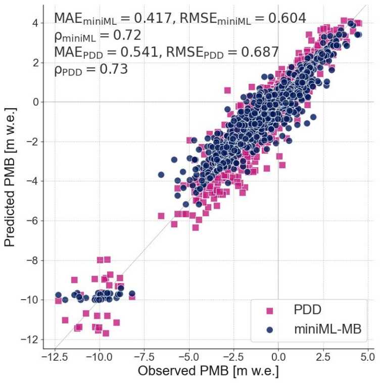
Glaciers in the European Alps are losing mass and retreating, a phenomenon that has been accelerating since the 1980s because of human activity and is projected to continue in the future. The environmental and societal consequences of this decline are substantial, underscoring the need for accurate representations of glacier evolution through measurements and models. A central concept for describing glacier evolution is mass balance (MB), which quantifies the change in a glacier's mass over time.
This project explores the potential of using a data-driven alternative to conventional numerical glacier mass balance models. We focus on developing global machine-learning glacier mass balance models driven by climate variables and topographical features. First, we simulate MB for individual sites (locations of MB stakes) and then expand our study to an ensemble of stakes on multiple glaciers. This capacity of the model will be particularly valuable for glaciers without glaciological measurements or new climatic conditions. Our global MB model is then harnessed to make glacier-wide and regional MB simulations in the Swiss Alps.
As glaciers thin and retreat, they leave behind eroded basins. This has important implications for the stability of valley walls. Unstable slopes in remote places may not be particularly hazardous to humans, but as tidewater or lake-terminating glaciers retreat, the risk increases that a landslide could fail into water, generating a tsunami and significantly enlarging the impact area. While several studies have identified a link between glacier retreat and slope stability, the role of the glacier specifically is still unclear.
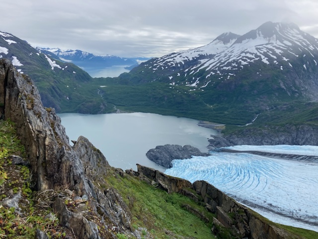
This project aims to better understand to what extent landslides can be (re-)mobilized by retreating glaciers. More specifically, it will investigate the glacial, thermal, and hydrological processes controlling slope motion at different stages of glacier retreat. Additionally, we will investigate why certain sites are more susceptible to instability or even failure. We focus on southern Alaska, an area currently experiencing some of the highest glacier mass loss rates in the world. We use remote sensing, in-situ observations, and modeling. Fieldwork provides site-specific information at Portage Glacier, Alaska, where a landslide is currently being debuttressed. Our multi-year investigations will illuminate how the landslide responds to the glacier and other environmental factors.
This work will improve our understanding of glaciers’ role in initiating or exacerbating slope failures. Its results will be of broad relevance for any rapidly deglacierizing region on Earth.
Glacier water pockets (GWPs) are elusive bodies of liquid water that can form within glaciers. The term is most often used in conjunction with glacier floods, which can happen when GWPs suddenly release their waters (so-called "GWP-ruptures"). Being invisible from the surface and very difficult to detect, GWPs pose a real hazard for the areas downstream. An influential analysis of the 1980s estimated that about one third of all floods observed from Swiss glaciers originate from GWP-ruptures. Although this estimate seems remarkably high today, GWPs remain amongst the least understood features known to exist within glaciers.
This project sets out to fundamentally advance our understanding of GWPs, and to answer some long-standing questions including: How often do GPW-ruptures occur and what are the magnitudes of the related floods? Which morpho-climatic factors determine the presence of GWPs? How can the locations of GWPs be determined, and which morphologies do they have? Which mechanisms control the temporal evolution of GWPs, and can their ruptures be predicted?
To answer these questions, the project will combine (i) information from historical data and reports, (ii) extensive field observations acquired by former projects, (iii) in-depth geophysical surveys for selected locations, and (iv) numerical modelling of the relevant physical processes. We anticipate the project findings not only to be of strong interest to the broader geosciences community, but also to be of direct relevance for public and private actors in charge of managing glacier-related natural hazards and downstream infrastructures.
The Himalayan mountain range is characterized by extreme topographic gradients and a substantial glacier cover consisting of several ten thousands of glaciers of different sizes. These glaciers represent a crucial element of the hydrological cycle, as they feed the large streams of the Indus, Ganges and Brahmaputra. Past, ongoing and future changes in climate conditions have major consequences for Himalayan glaciers, thus raising concerns about water security across the Indian subcontinent.
This research project sets out to shed light on key aspects related to small Himalayan glaciers, as well as to their hydrological relevance. Focusing on glaciers smaller than 2 km2 , it aims at better characterizing their present state based on improved observational techniques at a benchmark site, their future evolution using enhanced glaciological process-based models, and their effect on local to regional hydrology with a special focus on future changes in interannual variability. The project builds upon a combination of in situ and remote observations, as well as upon process-based numerical analysis that includes both glaciological modelling at high spatial resolution and streamflow modelling at local to regional scales. The combination will result in the first detailed study on the present and future state of small glaciers in the Himalayas and on the impact of 21st century glacier melt on water availability.